| Exercise | GeoLocation |
| Overall Goal | Use Real World GeoLocation to Locate a Model |
Overview:
The purpose of this exercise is to update an existing Workspace that locates a model and place it at your current location. It demonstrates both how data can be returned for a given location but also how a 3D model can be located and placed at a real world location.
The accuracy of the model placement depends on the GPS signal and accuracy, and is best done outside with a good view of the sky. However as technology improves and the blue-dot moves inside this can also be used to geographically locate models within the building.
To get the best accuracy keeping the device near a Window so it gets a good GPS signal will help model placement.
The existing Workspace
Follow the instructions in the video below to add the ability to pick up the location from the Data Express App. Use the following location if you need a test location {"latitude":53.399415,"longitude":-6.348068}
The instructions use this workspace C:\FMEData2020\Data\IMGS\AugementedReality\TardisPublic.fmwt which can be opened in FME as the first step of the Exercise below.
The model can be published to any repository with any name for the workspace so just replace the names and connection with your FME Server details and preferred repository details.
Run in Data Express App:
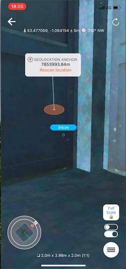
Open the model inside the FME AR app, and navigate around the model. Clicking on the ViewPoint locations around the model will jump you to each pre-defined location.
The model will prompt you to move the model to its geographic anchor if you open it away from the anchor location defined by the GPS coordinates above. Tap the orange circle and select move to location if required.